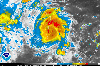
Figure 1: Hurricane Ida making landfall on the Nicaraguan Coastline early this morning
I blogged this summer as Dr. ‘Cane and thought I’d post one more time here in the the PG as the tropics are trying to give one last hurrah before winter slams down his icy fist.
As we head into November, a hurricane is not something you would generally expect to see, especially given the utterly unremarkable hurricane season of 2009. However, that is just what we have. Hurricane Ida spun up very quickly over the past 24 hours in the extreme southeastern Caribbean Sea, going from a tropical depression at this time yesterday to making landfall on the eastern Nicaraguan coastline this morning as a 75 mph hurricane. It ranks as the sixth most rapidly intensifying cyclone on record, strengthening to a hurricane in exactly 24 hours. In what has to date been a very quiet hurricane season, particularly in the Gulf of Mexico, Ida has the potential to make the rig operators of the Gulf breath a bit heavier for the next week or so. Ida’s forecast track is shown below.
IdaMap2

Figure 2: Projected path for Hurricane Ida
Ida made landfall this morning in Nicaragua and will likely remain just onshore for the next 48 hours. This will result in rapid weakening with the storm likely being downgraded to a tropical depression at some point. Having been inland for only about 4 hours, Ida is already looking rather ragged. Should the storm make it far enough inland to interact with the mountainous spine of Central America, it is even possible that the system may dissipate all-together. Ida is a very compact system, which makes it more vulnerable to land interaction. Thus, I give the storm a 40% of dissipating over land, which is a little bit higher than the model consensus. However, should the storm continue its present movement due almost north, it should emerge into the western Caribbean Saturday morning as a week tropical depression. Even though it is mid-November, the ocean temperatures of this region are very warm and upper level winds are forecast to be unusually favorable which should give Ida an opportunity to intensify. The map below shows the oceanic heat content available to the storm on its projected path. Generally, values above 50 kJ/cm^-2 permit strengthening while values about 80-100 kJ/cm^2 permit rapid strengthening, assuming favorable upper-level conditions.
IdaTCHP

Figure 3: Heat content ahead of Ida. Note the particularly warm western Caribbean.
There are two potential tracks for Ida once it exits the Caribbean (assuming it survives its trek over Central America). Should the storm continue due northward into the central Gulf and threaten the oil and gas infrastructure in that region (see Figure 1), water temperatures quickly cool off and hostile upper level winds increase. This would result in significant weakening and Ida would not make landfall as more than a minimal to modest tropical storm. On the other hand, Should Ida make a turn to the east once it reaches the Gulf, as some models are now suggesting, Ida could strike further south in Florida as a much stronger system, perhaps as Category 1 or 2 hurricane. Such a track would be similar to Hurricane Wilma in October of 2005.
Ida’s path will likely depend on its interaction with two other tropical systems in the vicinity. First, a weak tropical low designated Invest 96E is centered a few hundred miles to the west of Ida on the Pacific side of Central America. Should this system move northward, the counter-clockwise flow around it would help to steer Ida to the north. Should the system move to the west and out to sea, it could pull Ida west and further inland, resulting in a longer stay over land and probable dissipation. Second, a sub-tropical disturbance is located in the southern Gulf of Mexico and is moving slowly northward. Should this system strengthen as some models are calling for, the flow around it could help to drag Ida northward, as well as increasing its forward motion. In fact, some models are forecasting that the Gulf of Mexico may have to deal with two tropical, or sub-tropical, systems this upcoming week. The interactions of these three systems are shown below.
SatSituation

Figure 4: Interaaction between Ida and two other disturbances.
In regards tooil and gas rigs, should Ida move into the central Gulf of Mexico, it could certainly pose a threat to the rigs south of Louisiana and Alabama, albeit only as a modest storm. If Ida takes a track further to the east, it will be a much stronger storm, but will be too far away to affect the rigs. Personally, I like the eastern track more right now, as it is climatologically favored and is the direction the models have been trending. Historically, a 40-50 mph tropical storm moving across a rig-dense stretch of coastline may shut-in 20-30% of the rigs. Given that the Gulf of Mexico produces roughly 15-20% of our natural gas, such a shut-in would cut production by about 3-6%/day.
Related searches:
hurricane ida, weather channel, ida path, hurricane ike s path, national hurricane center